Borders and Boundaries

Borderland: A fascination with borders and boundaries

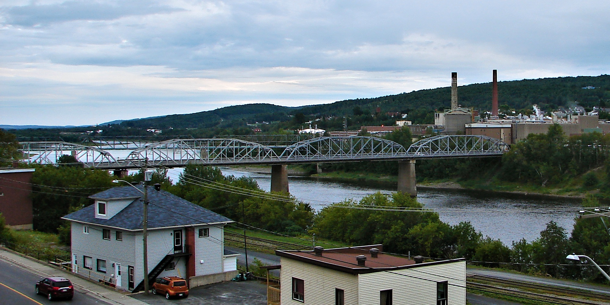
I’ve long been fascinated by international borders and provincial boundaries. It started back in 1975-76. First, I decided in the Summer of 1975, between Grade 12 and 13 at Oshawa Catholic High School in Oshawa, Ontario, that I might was well catch a bus, head east, and then experience the end of the hitchhiking era. Part of that would involve borders. I recall walking across the Edmundston–Madawaska Bridge, an international bridge which opened in 1921 and connects the cities of Edmundston, New Brunswick, in Canada and Madawaska, Maine, in the United States, across the Saint John River. A new replacement bridge is currently under construction and scheduled to open in 2025.

I’m not sure quite what propelled me to walk over the river and into Aroostook County, Maine, but I think there was something about a girl in a bar in Madawaska (I know, sounds a bit like the opening salvo of a country-and-western song; I believe the legal drinking age may have been 18 in Maine at the time). I remember me back in Canada later sleeping in front of either Edmundston City Hall, or the Edmundston Police Force station (I’ve forgotten which, but the building was downtown, near the old S.M.T. (Eastern) Limited bus station, I think, in those days).

Remarkably, I only had a summer-weight sleeping bag and packsack (and notably no tent) in late June in the Maritimes.

My next stop would be camping out with the same gear in  Charlottetown in the back yard of the Government House of Prince Edward Island, often referred to as Fanningbank, where I was again neither disturbed or arrested, albeit I don’t recall then Lt.-Gov. Gordon Bennett inviting me in for some breakfast either.

A few days later, my sleeping back and I wound up camping out for the night atop some embankment, surrounded by cedar trees, I believe, in Truro, Nova Scotia. When I woke up the next morning my sleeping bag and I had descended about 30 yards down the embankment during the night, while my packsack was still back at top, marking where we had started out.

The following year was the United States’ bicentennial. To mark the occasion in 1976, Canada’s official gift to the United States on its bicentennial was a coffee table-size book, Between Friends/Entre Amis, which was chalk full of exquisite border photographs, and introduced me to the International Boundary Commission. I gave the book to my parents for their anniversary that year.

Between Friends/Entre Amis was where I learned about places like the Haskell Free Library and Opera House, situated at 93 Caswell Avenue in Derby Line, Vermont and 1 Church Street in Stanstead Quebec. It straddles two nations, with one foot in the United States and the other in Canada. A black line running along the floor – a strip of masking tape – marks the international border, separating the towns Derby Line, Vermont, from Stanstead, Quebec. The front door, community bulletin board and children’s books are in the United States; the remainder of the collection and the reading room is in Canada.

In the Summer of 1979, I lived briefly in Blaine, Washington, directly across from 0 Avenue in the Douglas neighbourhood of Surrey, British Columbia. The houses on the north side of the street right were in Surrey, the houses on the south side were in Blaine. My neighbours across the street had British Columbia licence plates visible in their driveways, while neighbours on either side of me had had Washington plates in theirs.

In 1983, I remember tagging along on a trip or two to Akwesasne with Richard Russell, when he was the circulation manager of The Standard-Freeholder in Cornwall, Ontario, and I was a daily newspaper reporter there. This is also around the time I came to love Lancaster, Ontario perch rolls in hot dog buns.

Akwesasne is an incredibly complicated and complex place. Was then and is now.

I may even have enjoyed a pint or two back in the 1980s in the Halfway House, a tavern also known as Taillon’s International Hotel, where the barroom straddles the Canada-United States border between Dundee, Quebec and Fort Covington, New York, and that was built in 1820 before the international border in that area was surveyed. I remember the demarcation line drawn on the floor by the pool table, and admonitions not to transport alcoholic beverages from Quebec into New York and vice-a-versa.

Perhaps this borderland and interprovincial boundary fascination runs in the blood. I remember going to my birth mother’s place for the first time in August 1999. She lived near Amherst, Nova Scotia, on Fort Lawrence Road, east of Exit 1, where the Via Rail Ocean passenger train, with its haunting but not at all unwelcome whistle filling the air, en route from Montréal to Halifax, or Halifax to Montréal, crossing the saltwater Tantramar marshes between Amherst, Nova Scotia and Sackville, New Brunswick, a stone’s throw from the Missiguash River, bordering New Brunswick and Nova Scotia and connecting the Nova Scotia peninsula with those who come from away elsewhere in North America.

The saltwater Tantramar marshes, sometimes referred to singularly as the Tantramar Marsh, is a very special place indeed, and was even long before the first train crossed it in the 19th century. Memory surrounds you everywhere in Nova Scotia. This is the soil my Acadian ancestors lived and laboured on.  This is Aulac Ridge, a prominent rise running west to east across the Tantramar marshes on the Isthmus of Chignecto, just west of the Missiguash River. This is the demarcation line between Fort Lawrence and Fort Beauséjour, New France and British North America, New Brunswick and Nova Scotia, overlooking the Cumberland Basin of the Bay of Fundy.

You can also follow me on Twitter at: https://twitter.com/jwbarker22

Standard
hitchhiking

Hitchhiking down the road to Edmundston, walking across the water to Madawaska, Maine for a few beer, and camping out in His Honour’s back yard


I have fond memories going back to 1975 of my first long-distance hitchhiking expedition from Oshawa at 18, just after Grade 12, to the Baker Lake and Edmundston areas of New Brunswick, and then walking over the Edmundston-Madawaska Bridge, which opened in 1921, from Des Veterans Promenade, as it is known now (not sure about back then)  or Highway 2 to Bridge Street or US Highway 1 in Madawaska,  just across the Saint John River in Aroostook County, Maine.
 
I think there was something about a girl in a bar in Madawaska (I know, sounds a bit like the opening salvo of a country-and-western song; I believe the legal drinking age may have been 18 in Maine at the time) and me later sleeping in front of either Edmundston City Hall, or the Edmundston Police Force station (I’ve forgotten which, but the building was downtown, near the old S.M.T. (Eastern) Limited bus station, I think, in those days).
 
Remarkably, I only had a summer-weight sleeping bag and packsack (and notably no tent) in late June in the Maritimes.
 
Remarkably, no one either disturbed me or arrested me.
 
My next stop would be camping out with the same gear in  Charlottetown in the back yard of the Government House of Prince Edward Island, often referred to as Fanningbank, where I was again neither disturbed or arrested, albeit I don’t recall then Lt.-Gov. Gordon Bennett inviting me in for some breakfast either.
 
A few days later, my sleeping back and I wound up camping out for the night atop some embankment, surrounded by cedar trees, I believe, in Truro, Nova Scotia. When I woke up the next morning my sleeping bag and I had descended about 30 yards down the embankment during the night, while my packsack was still back at top, marking where we had started out.
 
One of my last stops was  Channel-Port aux Basques, Newfoundland, where I discovered endless fog and Pizza Delight, which had been founded seven years earlier in 1968 in Shediac, New Brunswick. While it would be another 24 years or so, Chez Camille Take-Out on Chemin Acadie in Cap-Pelé, about 15 miles east of Shediac, and also on the Northumberland Strait, would become my favourite fried clams joint anywhere, with John’s Lunch on Pleasant Street in Dartmouth, Nova Scotia, running a close second. Now if I could only make it back to check out the Shediac Lobster Festival!

All in all, this admittedly was not a particularly well-thought out adventure at the age of 18, but I was fortuitous in more ways than one. Along with not being disturbed or arrested, it didn’t’ rain for the 11 or so nights I spent under the starry Atlantic summer night sky, sans tent, and I wasn’t unduly tormented by mosquitoes or blackflies, both of which, I suspect, are not unknown to inhabit the Maritimes that time of year. 

Hitchhiking, at least in much of North America, is something of a lost travel adventure art that more or less disappeared around the time of my mid-1970’s trek to the Maritimes (with the odd exception such as Globe and Mail writer John Stackhouse’s insightful Notes from the Road cross-Canada series in the Summer of 2000.) Of course, fear reigns supreme now and no one is going to pick you up, right? Well, maybe not. About a dozen years ago now, and more than 30 years after my Maritimes saga, I did a fair bit of hitchhiking again in Ontario, down in Prince Edward County on Lake Ontario, or simply “The County,” as it is known to locals.If you wanted to meet some interesting County characters and hear some down-home stories, all you had to do was stick your thumb out. I did it many a time on the Wellington-Bloomfield-Picton routeOne Sunday morning a man picked me up in Wellington and drove me to Picton, all the while telling me stories about what he considered to be the two worst winters in the County in his experience – 1946 and 1977. In ’46, he was in school and the snow was so deep, he said, you could touch overhead telephone lines (not that it was advisable to do so) walking on top of snowbanks. But ’77 was even worse, he said, with the County briefly loosing a snow plow in Lake Ontario near Wellington; the military having to bring their big blowers out from CFS Mountain View to clear some areas; a couple of kids with their dad’s car hitting a snowbank on the way home from school in a blizzard and being stranded for several days in Bloomfield. In both 1946 and 1977, my driver said, the County was cut off from the mainland for five days straight. Then passing through Bloomfield, he told me about an-all-but abandoned house on the outskirts of the village toward Picton. Well, not quite abandoned. While there were no longer human inhabitants, the elderly woman who owned it, with some help from relatives, he said, still returned most every afternoon from her home nearby in the village to feed her birds, which still lived there on Highway 33.

Another time, I was picked up by a grandmother and her grandson while I was hitchhiking. Her family home had been in Bloomfield for 130 years. But she’d also travelled far and wide before her path took her back to the County. While she was well-known for many things, including being the spouse of a well-known-in-his-own-right Hallowell politician, less well known perhaps was the true fact that she gave Hollywood screen legend Clark Gable his last x-ray in Los Angeles in 1960.

You can also follow me on Twitter at: https://twitter.com/jwbarker22

Standard